Heavy rainfall is sometimes the discharge of a massive river of water vapour that flows through the sky, says S.Ananthanarayanan.
The nature of rainfall has been generally understood as winds picking up water vapour, which they release when they rise and cool, in the face of landmass. This simple picture has been enriched since the use of radar detection of motion and moisture content of air, with the help of the Doppler effect, and also satellite imaging, and these have revealed structure and unsuspected streams of movement of moisture in the atmosphere.
David A. Lavers, Florian Pappenberger and Ervin Zsoter, of the European Centre for Weather Forecasts, at Reading, and the School of Geographical Sciences, Bristol, in the UK, report in the journal, Nature Communications that the new understanding of the character of rainfall could enable early forecast of heavy rainfall events.
The early weather studies concentrated on winds with the help of the science of mechanics. An elegant discovery in mechanics was the Coriolis effect, which is a force that seems to act on anything which moves within a context that is itself rotating. A simple and the classic instance is of the movement of air, or the wind, across the surface of the rotating earth. Air moving towards the equator comes from the direction of the poles. As the movement of the earth, due to rotation, is faster at the equator than when nearer the poles, air approaching the equator finds the ground below rushing away to the east and seems to feel a westward force. And when the air crosses the equator, it moves to places that are moving slower than the equator and the air seems to feel an eastward force.
This understanding helped explain the movement of the monsoons and other wind currents and rainfall was effectively explained and then studied, with the help of data winds or movements of the air. Arrangements were made to measure wind speeds at a large number of places and at different altitudes, to generate a 3D map of winds. Sharing of data over large areas was used to see where the low and high pressures zones moved, and hence to predict where there was likely to be rain or fair weather. But the data was invariably sketchy or not exact and hence the predictions of where there would be high humidity and low pressure often went wrong.
Armospheric rivers
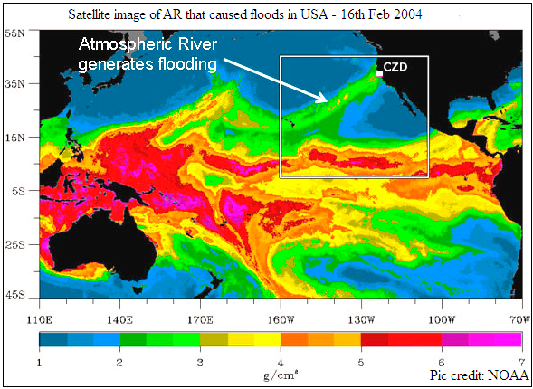
Better techniques and modern technology enabled more detailed study of the atmosphere and it was found that filaments of cool or warm air, with high moisture content, sometimes got generated in the interaction of tropical cyclones and these streams could push aside and penetrate bodies of air and transport moisture over long distances. Reginald Newell and Jong Zhu of MIT, in the later 1990s, proposed the name, atmospheric rivers, for these filaments, as they were narrow, could be massive and often moved hundreds of kilometers. These plumes of moisture, in fact, can be thousands of kilometers long and as narrow as just a few hundreds of kilometers wide. This is a huge cross section, in any case, and transports a great deal of moisture, and the water content in many of them can be larger than the water that flows through the world’s largest rivers.
These channels of water vapour, or atmospheric rivers, which are now known to crisscross the skies at all times, have now been seen as an important part of the global water cycle. Although they are narrow and extend to cover less than 10% of the earth’s circumference, they are responsible for 90% of the movement of water vapour from one hemisphere to another. And as they are at best unstable carriers of such great mass of water, they are the reason for most of the instances of concentrated and very heavy rainfall and devastating floods at places where they discharge their load. On the other hand, a large number of smaller instances of such channels are also the means for useful rainfall and the source for many of the earth’s surface rivers.
Predicting the weather
While this phenomenon of vapour transport is expected to become more acute with climate change, the UK team examined how reliable the study of the water transport, over long distances, rather than the local wind data, could be to predict rains and particularly major rainfall events. One hypothesis is that as the water vapour streams arise from much wider spread atmospheric processes, their progress would be less affected by local factors and hence more easily estimated. This principle was tested by the UK team, by making weather estimates for the British Isles in the winter season of 2013-14, when widespread flooding had occurred, and also across Europe, using both the Integrated Water Transport (IWT) data as well as the conventional methods of drawing conclusions from local rainfall growth data.
The results reported are that using IWT, or atmospheric river concepts, results in an increase of the forecast horizon by a whole three days. A mechanism for the higher predictability of IWT that is suggested is that conventional prediction depends on evidence of convergence of a vapour-rich mass of air. This could happen where there is upward movement of a current of air, like on encounter with a mountain. But in the case of heavy rainfall events, there is often no local wind movement data to help foresee the event. It is the study of the trajectory of atmosheric vapour streams, as indicated by IWT data, that provides more reliable pointers, which are less subject to break-down because of the uncertainty of parameters.
This proposed mechanism is supported by the study of the clear warning that was available, using IWT, as compared to what was used during the flooding events of 2012-14 in Europe. While how and where rainfall will occur is generally a complicated process, prediction from local data is unreliable because local data is highly variable. But IWT data is dependent on factors over a larger scale and shows resilience to local data variation. Data of movement of a vapour stream that could cause heavy rainfall at a place with the necessary topography could hence enable more reliable prediction of drastic rainfall events.
The UK team has demonstrated that this greater reliability of vapour streams as means to foresee heavy rainfall events permits making weather forecasts much earlier than with forecasts based on local build up of rainfall conditions. This is an important advantage that is now available with satellite based data, and all the more because modeling shows that heavy rainfall events would become more severe and frequent with Global warming.
While the UK team mentions the benefits to the flooding prone regions in Europe and western North America, atmospheric river study would also help early action in instances like the downpour over Mumbai in 2005 and the flooding at Uttakashi in 2013.
Do respond to : response@simplescience.in
------------------------------------------------------------------------------------------
