 (appeared in Aug 2016)
(link to main website)
(appeared in Aug 2016)
(link to main website)
We may start doing a lot better in forecasting the dates of the Indian monsoon, says S.Ananthanarayanan.
India’s economy, politics and personal fortunes have hinged, historically, on the timing and the adequacy of the monsoon, and again on being able to say when season would come to an end. Even moderate departures from expectation can result in misery, loss of crops or damage due to floods. Modern meteorology has helped a great deal, but there is still much uncertainty and the forecasts are possible no better than twenty one days in advance of onset. The implications of getting the date right and well in time, however, are massive, and every day’s improvement is a game changer in the region.
Veronika Stolbova , Elena Surovyatkina, Bodo Bookhagen and Jürgen Kurths of the Potsdam Institute for Climate Impact Research, the University of Potsdam, the Humboldt University, Berlin, the Russian Academy of Sciences, Novogorod and Moscow, the University of Zurich, the University of California at Santa Barbara and the University of Aberdeen, report in the American Geophysical Union journal, Geophysical Research Letters, that they are able to advance the date of forecast of the onset by a whole two weeks or more, and of withdrawal by a month and a half! The team of scientists would be proposing their method to the Indian Meteorological Department, says a press note from the Potsdam Institute for Climate Impact Research.

The current methods, which are followed by the Indian Meteorological Department, are based on statistical models that take into account the temperature, air pressure, humidity, at different altitudes above the Indian peninsula. The Meteorological Department has traditionally collected a mass of weather data, through a nation-wide and offshore network of sensors, balloon stations, wind speeds by radar tracking of metal targets sent up behind a rising balloon and lately, by Doppler radar equipment. Based on the data collected, and analysis of the records of past onset of monsoon, the approach has been to evaluate when the moisture load in the atmosphere must collapse as the monsoon. But these methods have limitations, the Geophysical Research Letters paper says, of being affected by anomalous movement of air masses and also when dealing with advanced or delayed dates of withdrawal of the monsoon.
The current team, in contrast, has viewed the onset of the monsoon as cascade that follows a build-up of tension, in the form of ‘tipping over’, like a block that suddenly topples when the base on which it stands is gradually tilted. An idea of seeking a component of the system which reaches a critical point, at which the system undergoes a rapid change of state, had been suggested by T M Lenton and others in a paper in PNAS in 2008, the authors say. The team hence looked for the component of the atmospheric system, the tipping element, whose growth may help forecast when the change, which is the onset of monsoon, would happen.
Tipping elements
The authors explain that the monsoon depends on many factors, the temperature, how the pressure varies between land and sea and the warmth being radiated when water vapour condenses, as also the shifting of the junction of winds from the north and from the south, an effect caused by the rotation of the earth, and the influence of the high Himalayan range. A characteristic of the onset of the monsoon is abrupt change in the movement of air masses and it is preceded by upward flow of warm air over the Bay of Bengal and the Arabian Sea, which carries water vapor with it to raise the high altitude humidity, they say. And the decline of the monsoon is marked by different air flow and replacement of moist air by dry air from inland, the authors say.
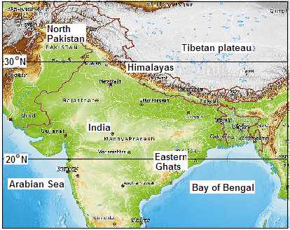
It is in this context that the team set out to locate ‘tipping elements’ that could help forecast the onset and decline of the monsoon. The data they used was the extensive, daily record of temperature, relative humidity and wind speeds, over a closely packed grid covering the region for sixty five years from 1951 to 2015. From this data, they worked out the variability of the temperature and of relative humidity at each of the grid points during a seven day window just before the onset of monsoon. They found that the growth in the variability of both the values studied was the highest around the Eastern Ghats, and North Pakistan regions. This feature led the team to choose these two regions as the reference points at which to look for linkage with the monsoon onset date.
Next, the progress of both temperature and relative humidity, both in North Pakistan and in the Eastern Ghats was plotted on a graph, over the days from before the beginning till after the end of the monsoon period, for all the years. The plots for both the indicators, for the two reference points, show a consistent relationship – the two trends rise and fall, as shown in the figure, and the plots for each of the reference points intersect, at which point the indicators are equal, twice during the period. And what is more, the days on which the intersection happens is right on the date, first, of onset, and second, the withdrawal of the monsoon!
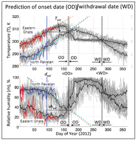
The team then used statistical methods to estimate the days on which this intersection of the plots would occur, based on the trend over the preceding fourteen years. A first approximation of the date of onset is by extrapolating the trend in the two reference points and comparison with the data of the preceding fourteen years. Closer determination of the onset date is by watching the trend of temperature in North Pakistan, which is steadier than in the Eastern Ghats. Another method for the onset date is with the help of the trends of relative humidity in North Pakistan. For the withdrawal of the monsoon, again, the trends of temperature in North Pakistan again helps fix the date. The relative humidity, however, is not useful for fixing the date of withdrawal, the authors say.
Successful forecast
The method of estimation has proved successful, within 7 days of the actual date, to the extent of 73% for the date of onset and 84% for the date of withdrawal. The merit of the method, the authors observe, is not in being able to pinpoint a closer date, as there is always uncertainty, but in being able to make the forecast from over a month to at least two or three weeks earlier, for the onset and a month earlier , for withdrawal, than what has been possible.
Difficulties in making out the trends of temperature and humidity in certain years have been seen to be the result of the El Nińo effect, a global ocean-atmosphere interaction. But monsoon forecasts for these years can still be made by the device of considering a ‘training period’ of not the preceding fourteen years, but the preceding fourteen El Nińo years, the paper says.
The study, apart from its obvious value for the economy of the Indian sub-continent, is illuminating about the nature of the monsoon. First, the authors explain, the idea of tipping elements highlights the interaction of a local weather phenomenon and a global one. The first is the coastal warming at the Arabian Sea and the Bay of Bengal ends, which brings about critical conditions at the Eastern Ghats. The global phenomenon is the shifting of the interaction of winds from the north east and the south west, which creates critical conditions in North Pakistan.
This apart, the idea of tipping elements helps us see that the abrupt onset, and also the withdrawal, of the monsoon arises from the cyclonic circulation of winds in the Eastern Ghats interacting with the reverse circulation, an anti-cyclone, in North Pakistan, with a role of the Himalayan ranges.
------------------------------------------------------------------------------------------
Do respond to : response@simplescience.in
