Great Britain has a long history of separating from the European landmass, says S.Ananthanarayanan.
Much of the British Isles is known to be a mound of chalk, deposited over ancient bedrock and covered with soil, except at Dover and plain of Salisbury, where the whiteness is exposed. A wall of chalk continues eastwards under the English Channel and appears again at Cap Gris Nez, on the French coast. A chalk ridge is understood to have once bridged the channel and theories of how it came to be breached have remained conjectures.
And in the same week that Prime Minister Theresa May has set in motion the UK’s economic separation from the European Union, Sanjeev Gupta, Jenny S. Collier, David Garcia-Moreno, Francesca Oggioni, Alain Trentesaux, Kris Vanneste, Marc De Batist, Thierry Camelbeeck, Graeme Potter, Brigitte Van Vliet-Lanoe and John C.R. Arthur from institutes in London, Somerset and Surrey in the UK and in Belgium and France report in the journal, Nature Communications, recent improvements in our understanding of how the physical, chalk connection between the British Isles and mainland Europe gave way to the English Channel. “This is Brexit 1.0 – the Brexit nobody voted for,” remarks Dr. Sanjeev Gupta, Imperial College, London
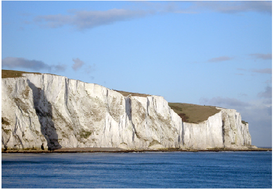
The chalk in the White Cliffs of Dover, extending across the Channel to northwest France, was deposited on the rock below in a warmer world a hundred million years ago, when this part of the earth was under water. Calcium carbonate, in the shells of single celled algae, the Coccoliths, sank to the bottom of the sea and gradually built up the mound that forms large parts of present day Britain. Rising of the earth’s crust and recession of sea water into ice sheets when the planet cooled lifted the land mass into view, with the British Isles connected by the chalk ridge with the rest of Europe. And then, during the ice age, 450,000 years ago, the waters receded even more and the entire English Channel was dry, a frozen landscape covered, at best, by sparse shrubbery.
The current understanding of how the chalk ridge was worn down and the now busy waterway, the English Channel, came to be, is that melting of icebergs created a vast pond in the North Sea, and the water was held back from flowing further south by the wall of chalk between Britain and Europe. Continued melt and discharge from rivers, the paper says, led to a spill-over which breached the wall and released a ‘megaflood’ into the low lying plain beyond the ridge. There is a network of valleys eroded in the bedrock in centre of the English Channel which have the signs of ‘high magnitude flood flows,’ which have been interpreted as the result of ‘catastrophic drainage’ of the build-up of glacial water, the paper says.
There are also other models of both less violent and sudden break-down of the barrier, where the lake to the north of the chalk ridge need not be proposed, or where there are other explanations for the furrows eroded in the downstream channel. The models, however, have not been tested, as there is little detailed data about the geological features of the sea bed in the places where the chalk ridge is considered to have been breached, the paper says.
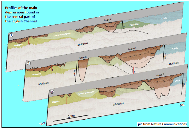
The first significant bit of information about the Channel seabed was what was discovered when the route for the Channel Tunnel, the undersea rail link between England and France, which runs as deep as 75 meters below the sea bed, was being surveyed. The direct route revealed a set of kilometres-wide depressions in the rock, filled with sand and gravel sediment. How the depressions, which were named fosse Dangeard (the word, ‘fosse’ means ‘deep’), arose was not understood, but the tunnel route had to be changed. An explanation of the depressions being caused by the waterfalls, which is like what has now been found to be the case, was attempted, but dropped for lack of detailed data to support the idea.
Collecting data
What the authors of the paper in Nature Communications have now done is to collate a great deal of the latest information, from maps of the seabed, geophysical data and maps of the bedrock, obtained by bouncing shock waves off the sea bottom, to piece together an explanation of how the data could all fit together. While the depth map was created using sonar based seabed surveys, the map of the bedrock was created using seismic reflections, where vibrations that pass through the sea bed get partially reflected when they meet the underlying bedrock. The reflected waves are picked up by an array of sensors and the structure of the reflecting surface can then be worked out
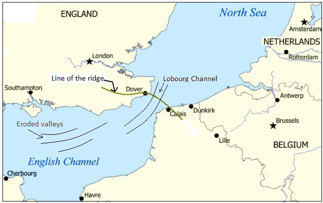
The depth map of the seabed shows a path of flow, a valley, the Lobourg Channel, that passes through the Dover Strait and into a network of valleys eroded in the bedrock further southwest, the paper says. The continuity of the Lobourg Channel and the eroded network downstream suggests that they form part of the same drainage system. And then, the path of flow, in the central part of the Dover Strait, contains the enigmatic collection of one-to-four-kilometres wide depressions. This group, the Fosse Dangeard, consists of seven main depressions, which go down as far as 140 metres deep, with flank slopes as steep as 15°.
Detailed analyses of the orientation, disposition and the nature of sediment with which the depressions are filled indicate that they are plunge pools, drilled into bedrock where kilometre-wide waterfalls landed, just as was suggested by Prof Alec Smith, Bedford College, London, in 1985. It is difficult to reconcile the depth of these features with any process of formation by flow of water or tidal erosion, the paper says. The depth of erosion, in fact, suggests that the waterfall was from substantial height, the paper adds.
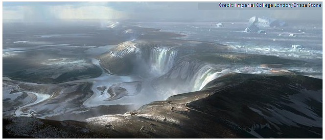
The picture painted is thus of “a huge rock ridge made of chalk joining Britain to France, looking more like the frozen tundra in Siberia than the green environment we know today……..a cold world dotted with waterfalls plunging over the iconic white chalk escarpment of the White Cliffs of Dover,” to use the words of Dr Jenny Collier, Imperial College. While this was the landscape of waterfalls is the first stage of the collapse, that explains the depressions in the seabed, it appears that this was the first stage, to be followed by a second, catastrophic breakdown and flood, that explains the erosion of valleys the bedrock downstream. “Perhaps part of the ice sheet broke off, collapsing into the lake, causing a surge that carved a path for the water to cascade off the chalk ridge……and an earth tremor.…weakened the ridge and….caused the chalk ridge to collapse,” says Dr Collier.
Improved understanding of how the Dover Strait was opened helps model how northwest European meltwater drained into the north Atlantic. It would also be useful to fix the time of when Britain became isolated from mainland Europe and the early human colonisation of the breakaway island, says the paper.
Reverse current
The study of the English Channel, reported here, can be said to have started with the mapping, by Imperial College, London, of giant seafloor valleys some ten years ago. Data collected from many sources have then been brought together.
Much of the seismic reflection data came from Belgian cruises and the data was processed at the Renard Centre of Marine Geology at Ghent, in Belgium. Soundings of the Channel seafloor were collected by UK Maritime and Coastguard Agency and the UK Hydrography Office and provided to Imperial College, London. Soundings of the French sector of the Channel were provided by the French Service Hydrographique et Océanographique de la Marine to the University of Lille.
And we see that the authors of the Nature paper are from the UK and different places in Belgium and France. The researchers, contrary to the current economic and historical geological trend, are collaborating rather than drifting apart.
------------------------------------------------------------------------------------------
Do respond to : response@simplescience.in
