Glaciers above 8000 m may disappear by mid-century, says S.Ananthanarayanan.
Why do you want to climb Mount Everest?the English mountaineer, George Mallory was asked.Because it’s there,he answered.Mallory&pos s expedition, in 1924, was perhaps the earliest of many that followed. Mariusz Potocki, Paul Andrew Mayewski, Tom Matthews, L. Baker Perry, Margit Schwikowski, Alexander M. Tait, Elena Korotkikh, Heather Clifford, Shichang Kang, Tenzing Chogyal Sherpa, Praveen Kumar Singh, Inka Koch and Sean Birkel writing in the Nature group journal, Climate and Atmospheric Science, describe an expedition, of 2019, with a more focused objective than Mallory’s. The National Geographic and Rolex’s Perpetual Planet Everest Expedition is “the most comprehensive scientific investigation of the Nepalese side of Mt. Everest thus far undertaken, including studies in biology, geology, glaciology, meteorology, and mapping,” the paper says.
Surveys of the lower Himalayas have been undertaken as part of the Survey of India since the early 1800s. Progress deeper into the Himalayas, however, was hampered because Nepal was reluctant to allow access to English surveyors. And not surprisingly, as it was the time of the ‘Great Game’ and States in and around the Himalayas were suspicious. Surveys of the higher peaks hence had to be from a distance, and the highest known was Kanchenjunga. More than one observation had shown that there was a higher peak, but given the distances, there was not enough data to be sure.
It was in 1852, that Radhnath Sircar, an Indian surveyor, from Bengal, identified the world’s highest peak. This was based on data collect by James Nicholson, who had made several observations from distances of over 174 kms away, but was prevented by Malaria from completing the analysis. The discovery was refined and verified over the next few years and in 1856, Andrew Waugh, Surveyor General of India, declared Kanchenjunga, designated Peak IX, to be at 8,582 m while the higher peak, then known as Peak XV, was at 8,840 m.
This figure is now more accurately known and is accepted at 8,848.86 m (29,031.7 ft). And over the last century, Mount Everest, as Peak XV has come to be known, has been a popular mountaineering objective. Apart from being the highest peak in the world, ascent of Mount Everest has challenges like powerful winds and changing conditions. And the region is one of the most glaciated in the world, outside the poles. But formal, scientific enquiry into the key factors that affect climatic conditions has not been conducted so far, the paper says.
The area, however, is of great ecological significance, and particularly as the source of sustenance for large populations. The world over, it is estimated that some 300 million people depend directly on glaciers and 1.6 billion people depend on mountains for fresh water. And 50% of the Earth’s biodiversity centres are in mountain regions, the paper says. And with glacial melt that has set in with global warming, understanding the mechanics of the climate at high altitudes has become urgent, the paper says.
The thrust of the 2019 scientific expedition was hence to study the “key drivers influencing atmospheric circulation, changes in snow and ice extent over time, and climate model verification.” These factors, the paper says, “together will decrease uncertainty in the climate change projections needed to plan a sustainable future.“
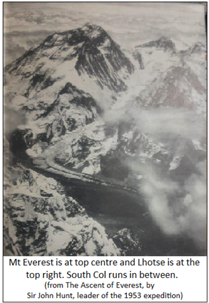
A peak that is adjacent to Mount Everest is Lhotse (South Peak, in Tibetan), which is the fourth highest (after K2 and Kanchenjunga) peak in the world. And the lowest point, or the col, of the ridge that separates the two peaks, is South Col, 7,900 m (26,000 ft), from where the final assault on Everest is launched by mountaineers. And over South Col flows the South Col glacier. As the region is swept by high velocity winds, most of the glacier’s snow cover is blown away and the glacier’s ice face is exposed.
South Col glacier (SCG) has been facing severe loss of ice mass in recent years. An objective of the expedition was hence to assess the timing and the causes of this loss, and the implications for other high mountain glacial systems. To this end, a ten-meter-deep ice core, which records the conditions over past years, was recovered, at the SCG. And automatic weather stations, the world’s highest, to monitor current conditions, have been established at the SCG and a nearby feature called the Balcony.
The ice core is only ten metres, from 30-50 m of ice, because the average temperature of -26⁰C, low oxygen, and winds, only permit two hours of drilling into the ice.
The age of the upper 10-69 cms (about 2 ft) of ice was estimated from the micro-sized aerosol particles trapped in annual snowfall that builds up the ice, and the age comes to 1,800 to 2,000 years. Techniques that have proved effective in nearby glacier were able to identify the rate of build-up of ice as 27 mm every year. Over 2,000 years, this should grow to 54 m of ice. Using the data of the nearby glacier, after allowing for differences in age and snowfall, the depth expected is estimated at 108 m, which suggests about 55 metres less ice thickness at the SCG. A figure that would be close to the ice thickness loss.
To work out the timing of this ice loss, the authors used existing records, photo-records, ice core and meteorological records, and statistical analysis. Putting together the records of 112 Himalayan glaciers covering the period 1812 to 1965 showed that glaciers had begun to recede, in parts as early as 1860. Glacial loss got more common and became the trend by 1950, and really speeded up by 2000, the paper says.
Another analysis of climate trends, going back to 1950, showed that there was large scale warming over Asia, with significant warming over the Tibetan plateau from the late 1990s. The focus of the study over Mount Everest shows sharp contrast of the pace of warming before 1950 and the intense warming after late 1990s, the paper says.
In order to see whether the trend of glacial ice loss corelated with this trend of warming, the authors carried out trials with how changing air temperature, relative humidity, wind speed, snowfall, short and long wave radiation affected the pace of loss of mass at the surface. What they found, over the period from 1950 to 2019, is that the main process of mass loss is sublimation, when ice, or snow cover, turns into vapour without first thawing as water. While rising temperature is found to be the key factor, over the SCG, the high wind speeds accelerate sublimation, although they could be expected to retard melting.
A next trial was with exposed ice, that is, without a snow cover. Here again, sublimation was the main process, except that it was now twenty time more marked, over melting, than when there was snow cover. This is significant, the paper says, for the SCG, which has scant snow cover. And in other places too, the faster sublimation of snow would deplete the snow cover!
The finding shows that current theories of glacial shrinking need refinement. The primacy of sublimation in the process adds to how sensitive high-altitude land masses are to changing conditions.
Climate predictions for the Himalaya all suggest continued warming and continued glacier mass loss.....even glaciers such as SCG that are above 8000 m may disappear by mid-century,the paper says.------------------------------------------------------------------------------------------ Do respond to : response@simplescience.in------------------------------------------- 